
#09 - The Scargazers Visit The Scablands
3/12/26
One of the joys of RV travel is learning about new places from other travelers. While visiting Mount St. Helens in Washington, another couple were sharing their travel path from the east and this amazing place called the Washington Scablands. Just the name piqued my interest, and it seemed obvious that the Scargazers should visit the Scablands.
History of Discovery
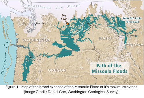
What exactly are the Scablands, and how did geologists come to understand their dramatic origin? The story begins with the landscape itself. As settlers traveled west, the lands of eastern and central Washington were generally viewed as poor areas to settle because the land wasn’t good for farming. In the early 1920s a geologist named J. Harlen Bretz proposed that this area was formed by a massive catastrophic flood, naming the area the “Channeled Scablands.” Other geologists considered his hypothesis as outrageous and rejected it outright since it was assumed all landscapes were formed by slow, gradual processes. The debate went along for many decades until other geologists joined the research, and the catastrophic flood idea became generally accepted in the 1960s and they generally accepted the water had come from a glacial dam that formed the historic Lake Missoula in Montana.
The Catastrophic Flood
During the latter stages of the ice age, as the earth’s weather began to stabilize, the ice sheets all over the planet began to melt. The melting that occurred in the northwest region of North America produced water flows that filled Lake Missoula, filling many valleys located in the mountains of Western Montana. Lake Missoula was estimated to be 2,000 feet deep near the ice dam located in northern Idaho and was estimated to contain around the same amount of water currently in two of our Great Lakes, Lake Erie and Lake Michigan. When the ice dam broke, it released all that water over a very short period of time, catastrophically shaping the landscape throughout central Washington all the way along the Columbia River out to the ocean.
It’s estimated the water flowed out over two weeks — so we can see what large volumes of fast-moving water can do in a short period of time! What an amazing illustration for those of us who believe the Biblical Timeline, that from Creation to today has only been around 6,000 years. Imagine what a five-month-long global catastrophic flood could do to the entire earth’s landscape.
The Leftover Scars
As I’m sure you can imagine, the flood scar would be huge as the water traveled all the way to the Pacific Ocean. The following diagram from the National Park Service is a great overview of the path of destruction.
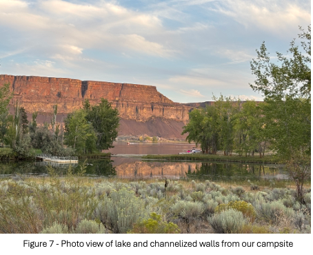
Some of the highlights for us were learning about coulees — they are deep ravines or gulches, usually dry, that were formed by running water. The Coulee Dam blocks one of those ravines that runs all the way to Canada. We also saw large ripple marks all the way from the coulees to the Tri-Cities area. When up high, looking into the ravines we saw potholes caused by underwater tornadoes that geologists call kolks. Like much of the Pacific Northwest, the landscape is mostly covered with basalt formations and ancient volcanoes.
RV Travel and Camping Tips
We drove to this area from the south along the Columbia River. There are two paths through the Tri-Cities region — we had already experienced the steep climb and windy stretch heading north on Route 82 and wanted to find an alternate route. We found a gorgeous drive along Routes 730 and 12, both following the Columbia River into the Tri-Cities — highly recommended if you’re traveling with an RV! From there we headed north via US-395 to SR-17, which brought us all the way to Steamboat Rock State Park where we camped for a few days.
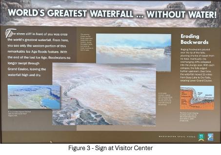
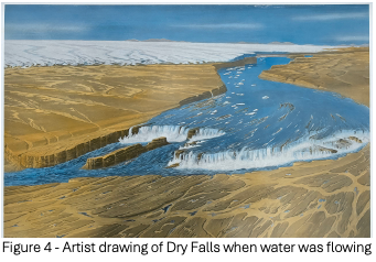
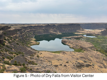
We stopped at the Grand Coulee Dam visitor center and picked up a great piece of trivia — the landscape would have allowed the dam to be built even taller, but international treaties prevented the reservoir from backing into Canada, so the dam height was set to keep the lake entirely within US territory. We also visited the Dry Falls overlook and drove the roads inside the flood basin — what an incredible visual of what a massive volume of fast-moving water can do in a very short period of time!
Quick RV Tips
Gas Stops – This is a remote area, so pay attention to distances. We filled up in Moses Lake and Electric City.
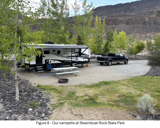
Campground – We stayed at Steamboat Rock State Park, they offer varying levels of amenities, we chose a large full-hookup site, and everything was well maintained and worked great. This is also a popular boating area, so many of the amenities focus on fishing and boating. As a state park campground, this is highly recommended.
-Greg and Sheila