
#06 - The Grand Staircase – Part 2
The Great Sediment Removal
Welcome back to our long overdue amazing journey through the Grand Staircase! In Part 1, we highlighted how the magnificent formations of Bryce, Zion, the Grand Canyon, and the other levels of the Grand Staircase are all related. We looked at what we can actually see, and in this newsletter we'll explore what’s missing and see if we can piece together where it may have gone.

1 - The top of the Grand Staircase at Yovimpa Point in Bryce Canyon National Park
The Story of What's Missing
On a recent visit to the top of the Grand Staircase at Yovimpa Point in Bryce Canyon National Park we saw people from all over the world looking out over the landscape. I think it’s safe to assume that most didn’t realize what they were seeing, or not seeing, as the case may be. As they gaze at the vast area below the rim of Bryce, does it even occur to them that something is missing, and if so, to wonder where it went? The famous cliffs that highlight the staircase aren’t in view from this direction, but you can clearly see the steps if you look at the landscape behind us in Photo 1. In Bryce, there’s no river that can take credit for the removal of such a vast amount of material, so it’s interesting to read the national park signs that add the magic of time to explain the landscape. (Figure 2)

2 -Park Sign, Bryce Canyon National Park
So, what do we see? We know the sediments deposited during the first phase of the worldwide flood were uplifted in the Grand Staircase region. The image of water removal of an uplifted landscape (Figure 3) shows how the landscape steps we see could have been shaped. What makes it interesting is the Grand Canyon is located at the top of the upwarp.
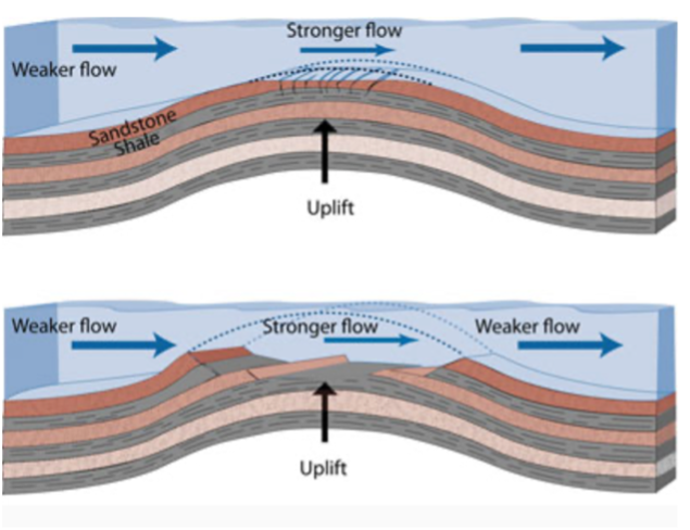
3 - Fast water erosion of an uplifted region
The amount that appears to have been removed is truly mind-boggling. Geologists estimate that between 5,000 and 10,000 feet of sedimentary rock (one to two miles) were stripped away from the Grand Staircase region, and that’s just based on what was left behind when the water finally abated.
That quantity of sediment removal represents approximately 40,000 cubic miles of sedimentary deposits from the first phase of the flood that was eroded away and transported elsewhere. That's enough material to bury the entire state of Rhode Island under 20 miles of debris! The energy required to accomplish such massive erosion and transport defies explanation by normal geological processes operating today.
Here’s a Google Earth view looking north of the overall area with Bryce Canyon, Zion, and the Grand Canyon circled in red. The whole area between those three circles is the Grand Staircase and what this article is focused on. Bryce is the top level, Zion represents the middle level, and the Grand Canyon represents the bottom level of the staircase.
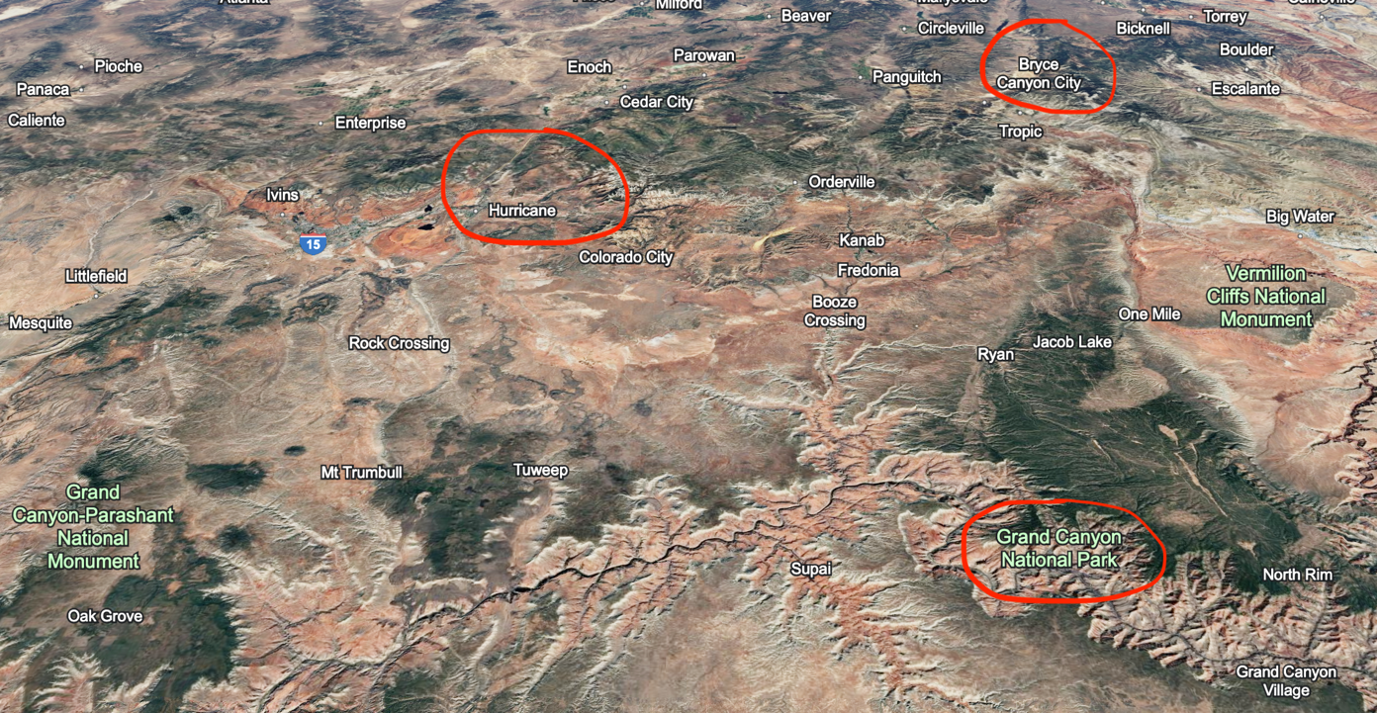
4 - Google Earth view of Grand Staircase region
So Where Did the Sediments Go?
Getting back to our mystery of the missing sediments, as best we can summarize, it appears sediments may have initially flowed southeast toward the Gulf of America, as we can see sediments that match that region out on the gulf shelf. At some point things changed, maybe as the Rocky Mountains began to rise, the flow switched towards a west and south direction. The immense scale of the water flows is truly hard to imagine, and the timing is merely a guess, but here's the picture that’s beginning to come together. We see matching sediments off the coasts of Texas, California, and Mexico, including the coastal plains of Los Angeles and Ventura County and all throughout the deserts of Southern California and Western Arizona. In the deserts we see many volcanoes and lava flows surrounded by non-volcanic sediments, some matching the Grand Staircase region, including the Grand Canyon. It’s easy to see why the Grand Canyon sediments could be so prevalent in the desert regions since the Grand Canyon exits just a bit east of Las Vegas.
As we observe the landscape in that region from Google Earth (Figure 5, Grand Canyon is circled in red), we can also see where the material flowing out through the deserts could easily flow into the Los Angeles Basin and the Oxnard plain in Ventura County. Most of the dark areas in the deserts are lava, and most of the light areas are sandy debris deposits. That flow of material likely didn’t stop at the ocean’s edge but may have also created much of the continental shelf. It’s just so enormous, it’s hard to fathom.
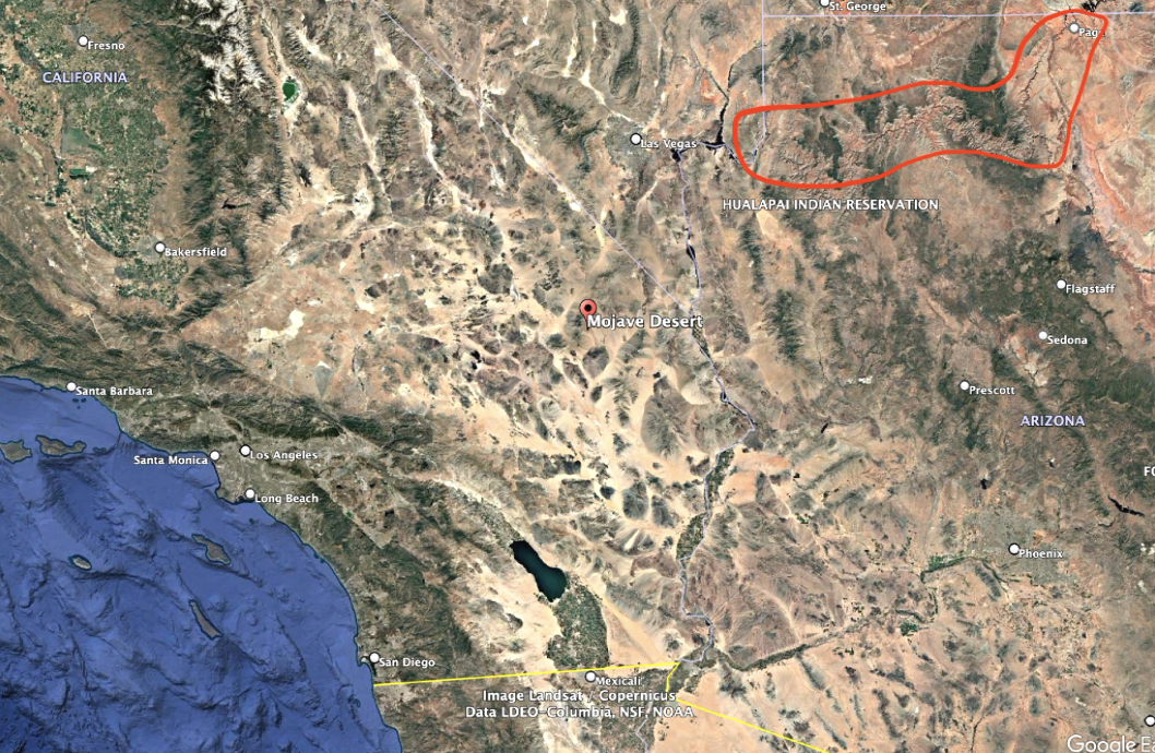
5 - Google Earth view of Southern California, Western Arizona, and Southern Nevada
The Need for More Evidence
This isn’t just speculation, it’s what we see from core samples that match the sediments found in the Grand Staircase region.
What we don’t know far exceeds what we do know regarding the dispersion of sedimentary deposits in the second phase of the worldwide flood, but there is work being done, primarily at the Institute for Creation Research (ICR) in Dallas, Texas. There’s a vast unused geological dataset available from the mining and oil industries where core samples have been taken and documented from all over the world showing what materials are found in these deposits. ICR has a team led by Dr. Tim Clarey that is working to document and categorize all that data and what is beginning to come into view matches what we would expect to see if the global flood actually happened as recorded in the Bible. That’s a newsletter for another day.
Integration with Biblical History
What we're seeing in the Grand Staircase region isn't just a local phenomenon, it's part of a massive, continent-wide reshaping of the landscape that was deposited in the first phase of the flood and removed in the receding phase of the flood. The evidence suggests that enormous volumes of sediment-laden water and mud carved, transported, and deposited materials on a scale that's almost impossible to comprehend, especially when using only present-day observable geological processes. It’s amazing to me that even in all that destruction God left His beautiful handiwork in so many landscapes that we get to enjoy today, roughly 4,500 years later.
Until next time,
Greg and Sheila Bair
Connect with us
Website and newsletter: scargazers.com
mailto: greg@scargazers.com
YouTube: coming soon
We welcome questions and comments and will reply personally to emails.
So Where Did the Sediments Go?
Recommended teachers and friends
Institute for Creation Research (ICR)
Creation Ministries International (CMI)
Answers in Genesis (AIG)
Creation, Evolution & Science Ministries